
2011 Trip across the US
2012 Trip across the US
2014 Trip across the US
2015 Trip to Alaska
2015-16 Southwest Trip
2016 New England Trip
2016 - 17 Southwest Trip
Friday, March 23, 2018 - Bolding Mill COE Campground, Gainesville, GA, Day 2 - 0 Miles, 6,626.9 Towing Miles For the Trip
After breakfast, I headed out to photograph some waterfalls. A real bummer - I discovered that my cherished B+W 77mm 6 stop & 10 stop neutral density filters are missing. The last time I used them was October 10, photographing some waterfalls in Oregon. These are necessary if you want to use the sweet spot of a lens (for most of mine it is f: 5.6) during daylight, long 5 second or more exposures. Even setting the D850 at f: 22 and an ISO of 32, the best I could do when the clouds passed over was 1.5 seconds using my 3 stop ND filter. So, I was limited to what I could do with these waterfalls. Not only that, but B+W filters are not inexpensive. Replacements will run around $150.00 each. Sure do wish I knew what happened to them. I do know that as soon as I replace them, the old ones will show up, but I checked every conceivable place I could have put them, both in the truck & the trailer.
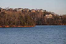
I also took a photo of some of the houses on the other side of the lake during sunset.
|
|
|
|
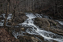
| Houses Across the Lake | Clay Creek Falls | ||
|
|
|
|
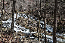
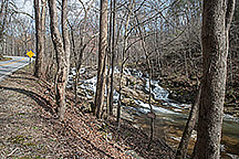
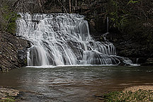
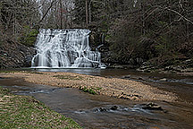
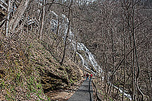
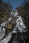
| Cane Creek Falls | Along Cane Creek | Amicalola Falls | |
|
|
|
|
| Amicalola Falls | Looking Down | Amicalola Falls | |
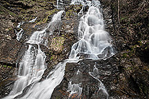
I went to three waterfalls, Clay Creek Falls, Cane Creek Falls, and the highest waterfall in Georgia, Amicalola Falls. Clay Creek is along Clay Creek Road, on private property with no parking space other than a one car pull off. You need to shoot from the road, with lots of brush in the way, but since I was there, I took a few photos. Cane Creek Falls is in Camp Glisson, and only accessible when the camp is open. There is a trail from a parking area to the falls.
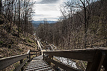
Amicalola Falls is in Amicalola Falls State Park. There is a $5.00 parking fee to get into the park. There is a 2 mile trail from the visitor center to the falls, or you can drive to a parking lot about 1/2 way up the falls, or continue on to another parking lot and lodge at the top of the falls. The view from the top wasn't all that good, and although there was a 455 step staircase to the mid falls viewing area, I decided to drive rather than climb back up the stairs. A short 1/3 mile hike between the parking lot & the viewing area. The park ranger at the visitor center said the middle view point was the best, & I have to agree. While it is the tallest falls in Georgia, much of the lower section is more like cascades that weave around enough that going to the bottom doesn't make a better photograph.
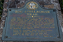
The park is also a drop off starting point for those doing the Appalachian Trail. The trail out of Amicalola Falls State Park is called the Appalachian Approach Trail, and meets the actual trail at Springer Mountain, 8 miles north. They had great looking Appalachian Trail "T" shirts, but only having walked about 5 miles of the trail in a couple of sections, I didn't feel worthy. Thankfully, the park also had a nice "T" shirt, so I bought one!
A total of about 65 miles on the truck, some on very narrow country roads. I got back to the campground around 4:00, and it was just warm enough to sit out in the sun eating in-the-shell peanuts. I have to do that outside or I get peanut skins all over the trailer.
Dinner was a Boston Market Sweet & Sour Chicken dinner. The first time I've seen them, and for a microwave frozen meal, pretty good.
Until Tomorrow -
This page is maintained by: vermilye@oswego.edu
Last Update:
March 24, 2018